How NCSU uses drone plant counts in study to guide replant decisions in cotton
August 23, 2023
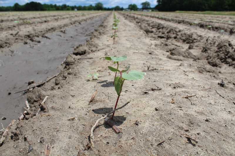
Replanting poorly germinated cotton is an economically high-stakes decision for growers. Increased costs from fuel and seed requires data-driven decisions rather than imprecise visual assessments. Finding a method to quickly and accurately quantify cotton plant populations was essential to agronomic researchers who wanted to reassess cotton replant recommendations.
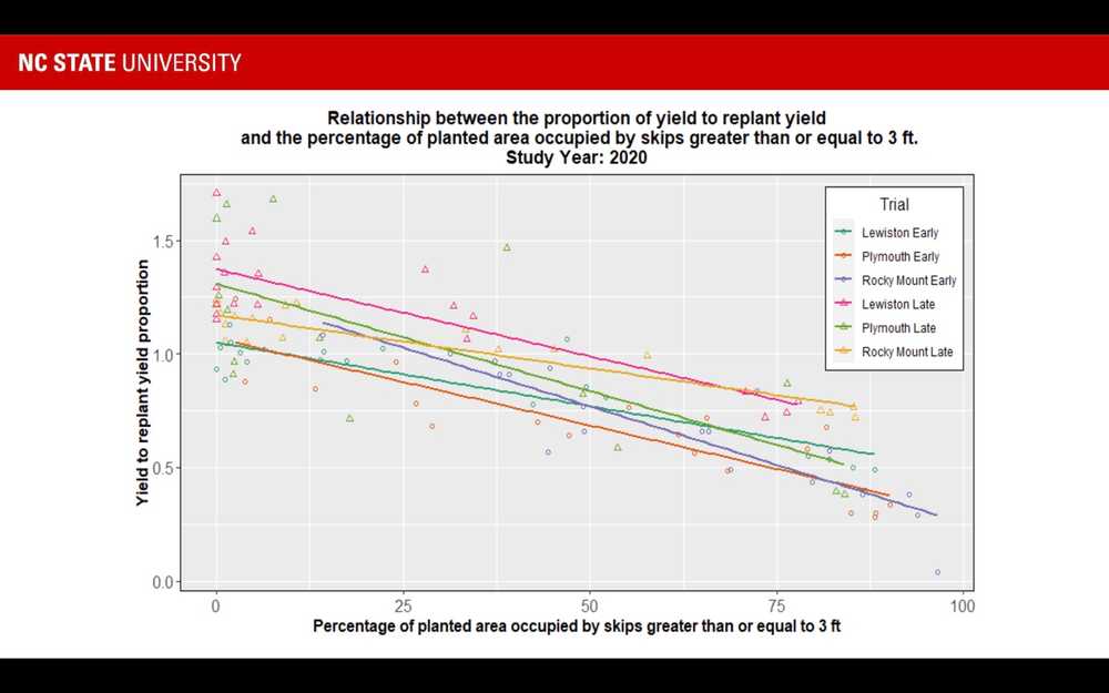
North Carolina State University researchers conducted a two-year study, funded by Cotton Incorporated, to better understand cotton replanting recommendations using UAVs (drones) to count plant populations and, more importantly, skips. Researchers found a refined economic replant threshold when 30-40% of a planted area consisted of skips greater than .91m (3.0 ft) in length.
A replant decision can change the trajectory of a whole growing season,” said Jason Ward, NC State assistant professor of agricultural engineering. “There are things that cannot be predicted, such as weather or markets, but we can put the crop in the best situation to grow at the time that the decision was made.
Study Design
Partner: NC State University
Crops: Upland cotton
Location: 3 research stations in eastern North Carolina, U.S
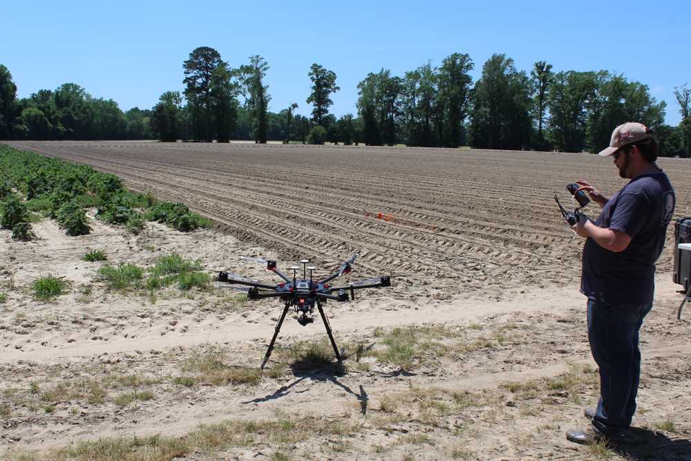
Hardware: DJI Matrice 600 Pro with Zenmuse X5 RGB sensor
Software: : Solvi Plant Counts with PlantAI, Custom Analysis Scripts in R
Flight Altitude: 30 and 53 meters AGL (Above Ground Level)
Number of flights: Each site was flown once per season
Image resolution: : 0.7-1.0 cm/px
Situation
Land-grant universities with strong extension programs need to make and update agronomic recommendations frequently for their grower clientele. For an economically important crop like NC cotton, current, data-backed decision tools are invaluable to growers who struggle with poor crop establishment.
Cotton growers face a host of variables when deciding if and when to terminate and replant underperforming cotton fields. Seed germination rates, emergence patterns, and seedling establishment are dependent on that planting season’s growing degree days, rainfall, and soil moisture.
Previously published cotton research indicated that plant populations above 49,000 plants per hectare (19,830/acre) were unlikely to result in significant yield increases and that skip size and frequency were red flags for replanting.
However, precisely quantifying large-scale plant populations was historically challenging; growers relied on representative row sampling or visual assessments to estimate their plant populations. And because late-planted cotton rarely results in optimal yield or quality, quick decisions are a must.
Researchers believed that growers may unnecessarily replant fields based on mere visual appraisals. And since seed companies have begun charging growers for replant seed ($35+/acre in 2020), replanting essentially costs a grower 56 kg/hectare (50lbs/acre) in yield. Quantification has become critical to crop profitability.
NC State researchers used drones for remote, quantifiable data acquisition at high spatial resolution for the earliest possible cotton plant detection. Their goal was to compare cotton plant population thresholds as well as skip size and frequency with lint yield. Solvi provided the drone image stitching and plant counting analytics that powered NC State’s own skip-identification algorithms.
Plant stand or population in cotton is simply not enough information to guide the replant decision alone - previous work has made that clear,” Ward said. “The big questions were ‘Could we use UAV imagery to guide that decision on a whole field basis? And if so, do the metrics need to be fine-tuned to give producers the greatest opportunity for success?’ Pulling a measuring tape on 200 row-feet to measure and count skips is a lot of work. We hoped to put a new tool in growers’ hands so that they could make decisions across the entire field rather than a single sample and better estimate their risk.
Download The Complete UAV Handbook for Agricultural Research
Learn how to establish a successful drone imaging program without a data scientist
Get your free pdfResearch Goals
The goal of the research was to use drone plant counts to:
- Find a critical skip size that best correlates with lint yield
- Determine the critical skipped area based on critical skip size
- Evaluate the yield potential and economic viability of replanted vs early plant cotton
Research Strategy
Each research site included trials of early and late-planted cotton with five plant populations: 100%, 75%, 50%, 25%, 10% and 0%. Replanted plots were seeded three to four weeks after initial planting to simulate a grower’s decision window.
Researchers flew drones over test plots after emergence to collect image maps and count plant populations. They exported the geolocated plant data by SHP file and further analyzed it in ArcGIS with R script to measure distances between and among reference plants and all others.
At harvest, lint yield was recorded for each plot and samples were lab tested for fiber quality.
This level of insight absolutely depends on high precision stand counts and skip identification,” Ward said. “We asked groups of growers and ag professionals to visually estimate the stand of a crop from both the ground and overhead images. The answers were inconsistent and inaccurate. Making the decision to replant when not necessary or to not replant when needed can both have negative impacts on profitability. The right data to make the right decision is essential in this case.
Drone Data Visualizations
Visual Field Mapping
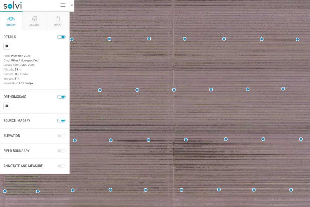
Researchers uploaded raw drone imagery to Solvi for stitching to digitally recreate fields in an orthomosaic map. This helps to visualize the spatial distribution of plants in the field. Datasets consisted of 300-500 images per location and were processed withing 30-60 minutes.
Plant Counts with PlantAI
Field inventory
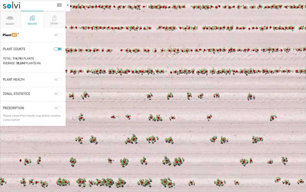
A complete field plant count provided a highly accurate plant population total to quantify and confirm trial plant population simulations.
Plant geolocation
Geotagged plant data was used to identify exactly where field skips existed, both in-row and adjacent. While long continuous skips were highly visible, smaller skips are less distinguishable to the naked eye. Plant location precision was foundational for subsequent analysis.
Data Export for Custom Analyses
NC State researchers exported datasets via SHP file for distance measurements and analysis in ArcGIS and by R-script.
The ability to have individual emerged plants automatically identified and geotagged enabled the entire analysis,” Ward said. “Other UAV platforms we tested did not have this feature, which meant that we would need to tag plants manually or create our own tools to identify individual plants. Having this within Solvi already flattened our development time to test out the actual hypothesis we were interested in.
Research Outcomes
- Cotton plants were successfully detected using drones. Detection was most successful when plants had four to six true leaves
- Flight altitudes of 30m provided better image resolution and earlier plant detection than at 53m
- Early-planted cotton could be assessed for replant and optimized yield
- Later season plant detection might cause producers to miss optimal planting windows or miss crop insurance deadlines
- No critical skip size was found. Many smaller (less visible) skips could have the same negative effect as fewer, larger skips
- Two replant scenarios were recommended:
- Fields with >50% skips of >.91m (3.0ft) could justify replanting when early-season conditions are warm and ideal.
- In more typical conditions, fields with 30-40% skips should consider replanting.
Drone imagery was needed for this study versus satellite data, as plants were counted and located at between two and four leaf growth stages. Ground sampling distance would need to be less than 2.5 cm/pixel to accurately identify the plants early enough to allow replanting to occur.
We recognized that growers who use UAVs to count plants could benefit from guidelines that explain how to measure skips and assess replanting needs,” Ward said. “We are pleased that the outcomes of this study accomplish that goal to make these financially-consequential decisions quantifiable.
Benefits of Solvi Analytics
Quickly and Accurately Quantifying Full-Field Plant Populations
Solvi’s cloud-based platform allows researchers to conduct all drone image post-processing and analytics in one place. From orthomosaics to plot extraction, plant counts, vegetation indices, and reporting, Solvi streamlines agricultural drone research.
- Complete all-in-one image stitching and analytics platform.
- Cloud-based for easy access and desktop freedom.
- Flexible to work with any RGB or multispectral camera and drone combination.
- Simple four-step imagery upload process.
- Highly accurate plant counts and health analytics.
- Clear, visual plot boundary maps and data results for research reports.
- Easy online sharing for full team access.
- Streamlined data exporting for custom analyses.
