How High Should I Fly an Agricultural Drone?
September 16, 2022
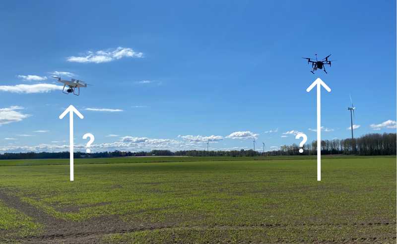
How high to fly a drone for agricultural field mapping is a common question among pilots. Since drone altitude impacts the resulting stitched image quality (and metrics available), getting it right can improve your crop datasets and reduce data losses or the need for reflights.
Drones Uplevel Crop Sensing
Stitched drone imagery creates a seamless, quantifiable field map from numerous photos. It’s 3-D digital photography up-leveled with location and scaled measurement.
Like all digital photos, drone images are composites of tiny colored square pixels – the smallest unit of a picture. Image quality determines how closely you can zoom in or enlarge an image before the detail starts to break down into visible pixels creating a grainy look.
On the ground, photo quality is mostly limited to your camera hardware and settings. But when digital photography takes flight on a drone, altitude and motion also affect resolution and the resulting data accuracy.
So, how high should you fly your agricultural drone?
Short answer - it depends on two things:
- the resolution (or in other words, level of detail) needed for the task at hand
- your drone hardware
Let’s zoom in 🔎
Agricultural Imagery Requires Detail
Your mission’s purpose determines the image resolution required for various metrics. So, what are you looking for?
For example, mapping field boundaries doesn’t require significant ground detail. If you can distinguish the borders and aisles, you can outline the field edges. You don’t need to see discrete plants or leaves, so a bird’s eye view will do, which is why a high-altitude image can suffice.
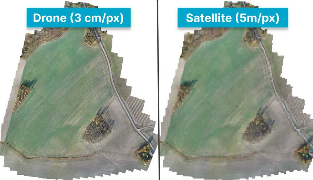
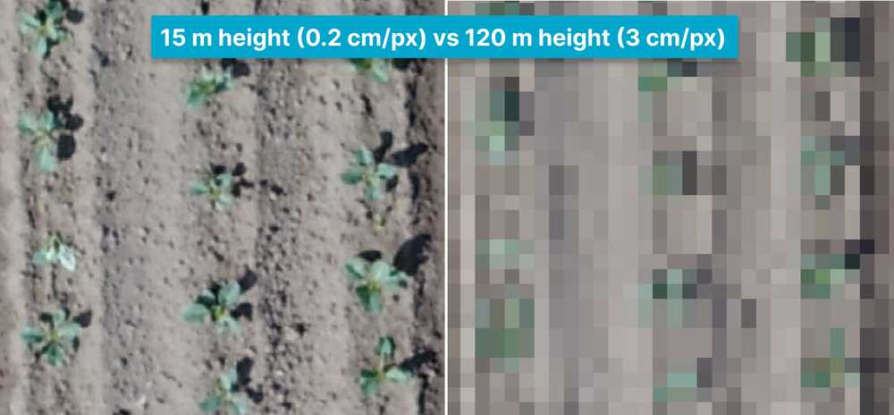
But in precision agriculture or plant research, evaluating leaf shape, plant health or emergence patterns requires ultra-high-resolution imagery to isolate, magnify and measure minute details from the air.
Drone image quality is measured as ground sample distance.
What is Ground Sample Distance (GSD) and Why Does it Matter?
Like all digital photography, drone image quality mostly depends on four variables:
- image size (megapixels)
- sensor size (sensor mm)
- focal length (lens mm)
These parameters are generally preset by the camera manufacturer. Unless you are highly experienced, we don’t recommend adjusting them on a drone.
Once in flight, we add altitude to the image quality equation and call it ground sample distance.
Here is how GSD is calculated:

So, to determine drone altitude, you first need to decide on GSD.
Ground Sample Distance (GSD) = Detail
GSD is the span between the centers of two image pixels - essentially, the size of a single pixel. It represents how much of the real-world scene detail is captured per image pixel.
Why Does GSD Matter? An Agricultural Example
Imagine overlaying enormous sheets of transparent graph paper side by side on a field, one divided into a few large squares (5m in size) and one has hundreds of tiny squares (1cm). GSD is the size of the squares.
In the large-square sheet, many plants appear in a single ‘pixel’ – not helpful if you want to analyze just one leaf. But using the tiny squares sheet, the pixels would blanket an entire plant. Now, you can zoom in to see individual parts of a leaf!
Low GSD means each pixel equals a smaller amount of field and therefore greater detail. If your plants or area of interest (like leaves) are small or in an early stage, you need lower GSD to analyze details. It’s like golf, where less is more.
Is Low GSD Always Better?
Better detail? Yes. Better overall? Maybe not. But if low GSD means better detail, why not just go low on every flight?
While it’s tempting to minimize GSD for every mission, low GSD comes at a cost - in expense, flight time, and/or image quantity.
Download The Drone Crop Scouting Schedule™ for FREE
Learn when to fly a field for actionable decisions and peak profits
Get your free pdfDrone Altitude - The GSD Variable You Control
Because most of the image quality variables are predetermined by your drone setup, the main variable you can (or should) control is altitude. But changing altitude has important workflow implications.
The Time vs Detail Trade-Off
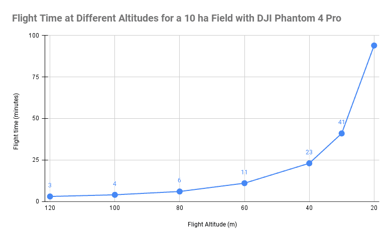
For a given camera and field area, a lower altitude means more details about crops will be captured, but it will also extend the flight length and number of photos (since each shot captures a smaller amount of land). Longer flight length means more of your time and battery life:
But longer flight time also means more photos will be taken, which translates to more storage and longer processing time:
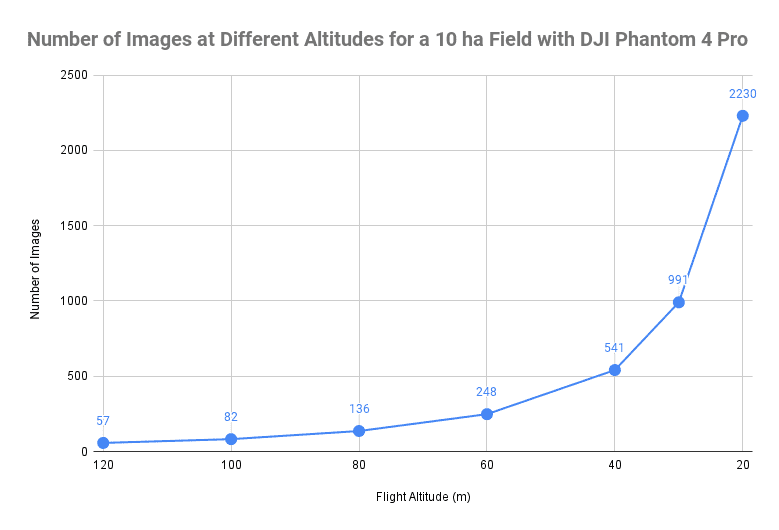
We recommend opting for the highest altitude (shortest flight/fewest photos) that still renders the detail needed for your mission (GSD).
Check Your Camera Specs
Many newer high-resolution cameras capture a low GSD (detail) at surprisingly high altitudes. So, know your drone camera specs. As an example, for the GSD of 0.50 cm/px, which is a common requirement for plant counts, you will need to fly at about 20m / 65ft altitude if you use a popular DJI Phantom 4 Pro drone. But with a more advanced (and expensive) DJI Zenmuse P1 camera on a Matrice 300 drone you can achieve same GSD at double the altitude (40m/130ft) saving you quite a bit of flight time!
Online GSD calculators (we like Propeller Aero’s) can easily confirm the GSD from your drone setup and planned altitude. It’s a good gut check to make sure your flight plan will produce the data you need.
Verify Drone Flight Speed
One tricky impact of altitude is the drone’s ground speed. Large images taken at low altitudes mean slower flight speeds to avoid motion blur. Flight software, like DJI Ground Station Pro, automatically adapts the drone speed to make sure images are sharp and crisp.
Agricultural Drone Altitude Best Practices
So, asking ‘How high should I fly an agricultural drone?’ is really a question of ‘What GSD do you need?’ With GSD decided, your drone camera settings determine the altitude for your mission.
The decision-making flow:

After processing thousands of flights at Solvi, we’ve seen a lot of trial and error. We’ve found that most drone missions fall into one of two categories: low or high detail (GSD).
Drone Altitude for Field Mapping or Precision Ag Management (Low Detail)
Creating field boundaries, mapping field elevation, or extracting trial plots doesn’t require extreme detail. Similarly, if your drone flights are for crop planning, diagnostic, crop monitoring, or prescriptive applications, a broad view is sufficient.
In good conditions, most drone cameras, including multispectral, easily capture 3-10cm GSD at a high altitude of 80-120m.
Target GSD: 3-10cm
Altitude: 80-120m (250-400ft)
Common uses:
- Field boundaries
- Topographical mapping
- Thermal imaging
- Plot extractions with well-defined boundaries
- Plant health maps (vegetation indices)
- Weed identification for spot spraying
- Variable rate prescriptive application maps
- Plant counts on large objects like trees
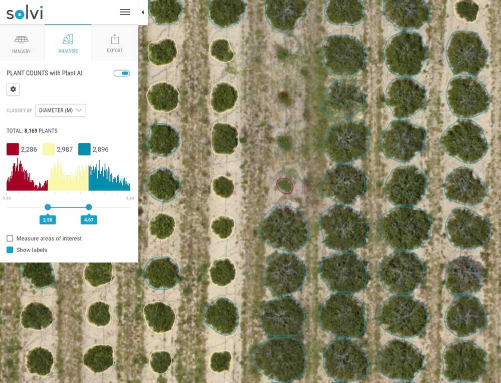
Drone Altitude for Crop Analysis or Plant Phenotyping (High Detail)
These crop evaluations require the greatest level of detail and photo quality. GSD should be minimized to <2cm and ideally <1cm depending on the desired metric, crop species, and growth stage.
Most drones will need to fly low at 15-30m. Newer cameras, including panchromatic sensors, may accomplish this detail at higher altitudes.
GSD target: <2cm
Altitude: 15-30m (50-100ft)
Common Uses:
- Evaluating emergence rates
- Plant counts in early growth stages in crops like corn, soybean, sugar beets, etc.
- Plant sizing, for example in pre-harvest vegetables like cabbage
- Plant density/gaps
- Plant height
- Characterizing varieties (flowering, leaf shape/color, fruit)
- Vegetable field trials with plant-level analytics
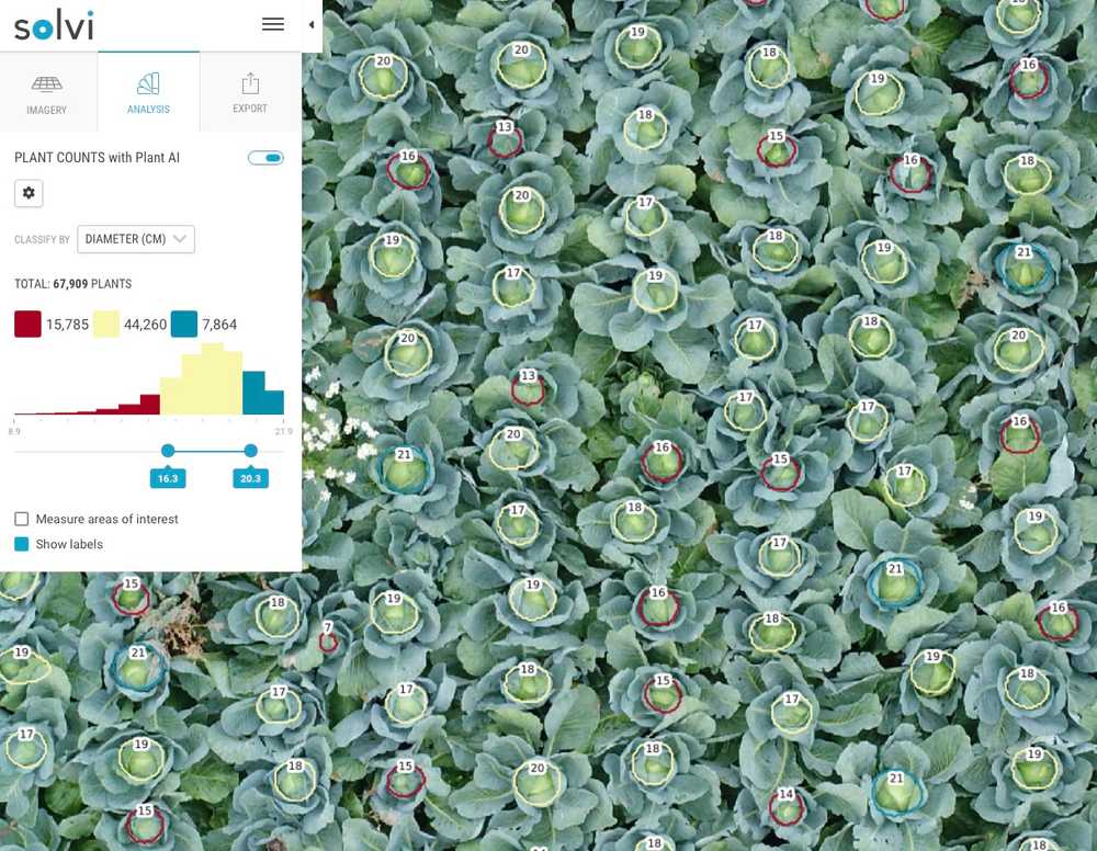
Adapt to Your Conditions
In reality, every crop and drone mission is unique. Weather, season, lighting, soil contrast, plant species and more will affect your GSD and flight altitude decision-making.
Use our best practices as a starting point and always adapt to your needs and field conditions. Still have altitude questions?
Solvi Simplifies Agricultural Drone Imagery
Drones should speed and enhance agricultural management and research. If your drone program is bogging down with poor-quality imagery, we can help.
Solvi simplifies agricultural drone imagery analytics so growers and researchers can focus on crops - not coding.
But simple doesn’t mean shallow. Our cloud-based analytics platform lets you dive deep into crop analytics with accurate plant counts and sizing, vegetation indices for plant health, biomass, fertility response, plant stress, and more.
Solvi is your one-stop for agricultural drone image stitching, analysis, and reporting for superior crop insights. Try your field imagery in Solvi for free today.
