5 Ways To Use Drones For Spring Crop Scouting
Last updated on March 01, 2024
Drones are an effective crop scouting tool for farmers to visualize, investigate, and predict crop performance. Whether you are a specialty vegetable grower or a small grain farmer, drone crop scouting can reveal important and objective data - while your winter crops are still in the field. Instant information gives you the opportunity to make mid-stream management decisions that can avert potential crop losses and even improve your crops’ performance.
Spring is one of the busiest times of year on the farm. Walking all your fields on foot is time-consuming and provides a limited perspective. Drone field mapping allows you to analyze an entire field at once to assess plant health and determine what, if any, additional management is needed.
Here are 5 ways farmers can use drones for spring crop scouting:
1. Evaluate Crop Establishment
Spring drone scouting can help growers determine if a large winter crop (like cabbage) is on track for a specified harvest date or has reached the optimum size maturity for harvest. Drone-based plant count analysis can also uncover early losses allowing farmers to assess localized failure causes (human or mechanical) and evaluate if the crop is economically viable for continued management and harvest.
Many brassicas, like cabbage, are particularly susceptible to winter diseases and rot that can result in significant economic losses. Drone scouting can identify rows or areas with winter damage or subpar growth for treatment.
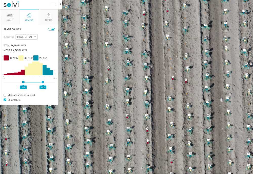
In row crops, like corn or soybeans, early-stage stand counts can help reveal potential issues with establishment of the crop and give an early indicator of yield potential. Having accurate stand counts across the whole field, rather than a few randomly sampled manual counts, can also be a crucial data point when deciding whether to replant the field or not.
Seasonal drone field imagery allows farmers to quickly pinpoint problems and respond while the crop is still in the field. This foresight can prevent crop losses and maximize crop quality through appropriate harvest timing.
Download The Drone Crop Scouting Schedule™ for FREE
Learn when to fly a field for actionable decisions and peak profits
Get your free pdf2. Create Prescriptive Nitrogen Application Maps For Small Grains
Winter oilseed crops generally receive the first half of their planned nitrogen rate in spring. Late fall drone field imagery can be paired with field biomass samples (using the cutting method) to generate a variable rate map to guide precise nitrogen fertilizer application.
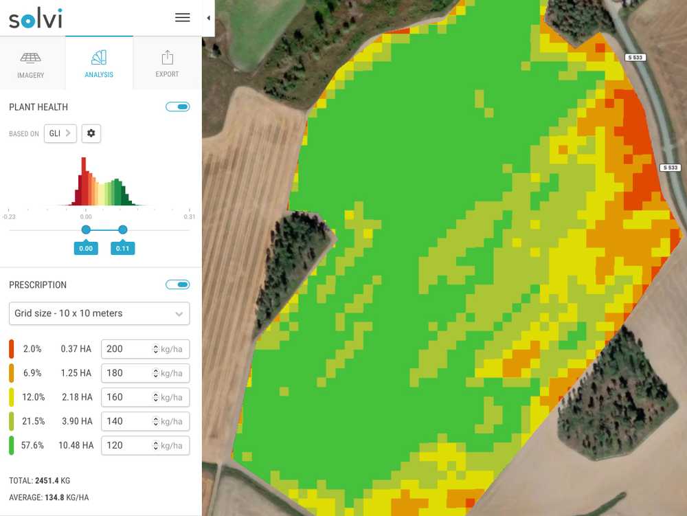
This time of year, cereal crops are also awaiting their spring nitrogen application. Spring drone mapping can help determine thin field areas that would benefit from an early nitrogen application. Especially for late sown or sparse field stocks, selective nitrogen application can provide a powerful boost to cereal crops lacking in root and side shoot development.
3. Establish a Crop Performance Baseline From Your Current Seeding Rate
Agricultural drone mapping can clearly identify farm field variations that cause spotty crop performance. These anomalies are often indications of soil variations. Identifying and precisely locating underperforming (or overperforming) areas allows farmers to investigate the root cause.
Once the locations are diagnosed (as low elevation zones, compacted soil, or soil type deviations), growers can make informed management decisions.
Variable-rate seeding becomes an easy and obvious choice for addressing chronic trouble spots. Having the flexibility to adjust your seeding rate allows a farmer to overcome localized underperformance while not overseeding and risking crop lodging in higher-performing areas.
If you are breaking ground on a new field this spring, soil mapping with an agricultural drone is also extremely useful to understand the plot’s topography and decide on the best land use. Visualizing differences in farmland allows a grower to adapt their crop allocation and potentially subdivide fields for best use.
4. Assess Spring Weed Pressure
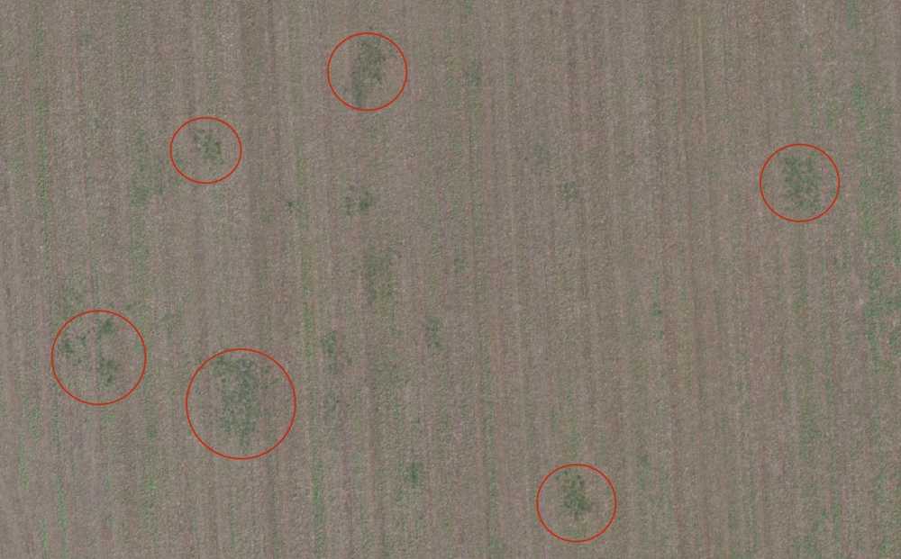
Prevention always beats treatment in weed management! Drone crop scouting can clearly identify and map weed spread within a farm field. At a glance, farmers can gauge whether weed pressure has reached an economically-important threshold to warrant treatment. If the weed population is low, farmers may opt to reduce, or even forgo, costly herbicides.
If weed pressure is significant, the PlantAI tool can be used to accurately identify and geo-locate weed outbreaks, allowing farmers to directly walk to GPS points in affected fields to identify weeds for accurate treatment. Outputs from the PlantAI detections can then be converted into prescription maps for variable rate herbicide application (or spot-spraying) - saving farmers money and reducing environmental exposure.
5. Identify and Assess Spring Field Drainage
As spring fields dry, agricultural drones can easily detect slow draining or drying areas. Drone field mapping can be used to create new drainage maps or target field inspections for troubleshooting. Farmers can then clearly evaluate where to direct grading or other field drainage solutions.
Avert Crop Loss With Spring Drone Crop Scouting
Field data captured by agricultural drones provide clear and objective information about a farm’s growing conditions. While drones are useful year-round, the busy spring season offers farmers opportunities to make management decisions while crops are still in the field. In-season crop monitoring and prompt response can prevent crop loss, improve crop performance and even increase crop yields.
Solvi Puts Predictability On The Map
Many farmers see the benefits and efficiencies of drone use on the farm, but are unfamiliar with drone technology or simply don’t have time to interpret their data.
Solvi is leading the way in drone analytics for farmers, agronomists, and plant breeders who want actionable insights from their data. Our Plant Counts feature provides accurate stand counts and plant size estimates so vegetable farmers can analyze entire fields or areas of interest at the plant level.
With our Plant Health Maps, it’s easy to convert drone-generated field maps into prescription files that can be directly used in spreaders for spring oilseed nitrogen application.
If it sounds high-tech, it is - but only behind the scenes. We turn your agricultural data into insights you can use today. Solvi’s machine learning algorithms make drone-based crop mapping simple, even if you’re new to drone farming.
